This was my first trip to Seoul, the capital of South Korea. When I travelled there in May, 2013 North Korea was threatening South Korea, and the United States, with open warfare, so there were fewer tourists travelling to South Korea during that time. Although there were fewer tourists, life in South Korea was pretty normal, and if you didn't read the newspapers or watch the news on television, you would not have sensed any type of fear or concern among the population in South Korea. However, the military was on high alert, and as you travelled closer to the border with North Korea a higher sense of military preparedness was present. The single most important place I wanted to visit during my stay in South Korea was the Demilitarized Zone [DMZ] and the Joint Security Area [JSA] on the border between North and South Korea. The only way to see this area was on an organized tour. I took a full day tour through the USO, which began at Camp Kim in Seoul where we boarded a bus for the drive north to Camp Bonifas at the DMZ. The drive was about 55 km in length and took about one hour. The drive was along a modern freeway which bordered the coastline which was heavily fortified with fences, mine fields and observation towers and gun emplacements. I took these pictures out the bus window in the rain as the bus was speeding down the road, so the quality is poor.


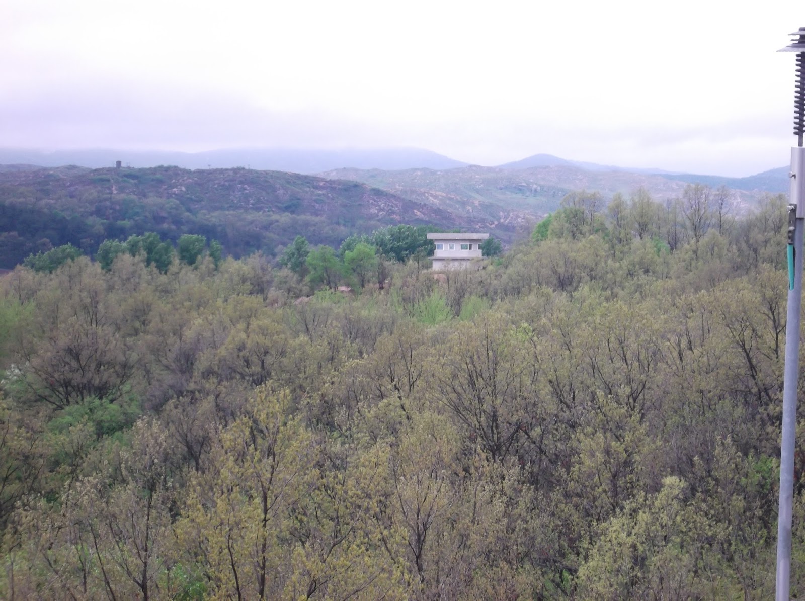
At Camp Bonifas [named in honor of a U.S. soldier that was killed in the DMZ by the North Koreans while cutting down a tree that blocked the view into North Korea. He was hacked to death by a North Korean soldier using an axe], we attended a briefing and short film about the DMZ and JSA, were assigned to our military escorts and transfered to a military bus for the ride into the DMZ. There were strict rules about what you could photograph [nothing on the South Korean side] clothing you could wear, and rules of behavior [no obscene gestures or language directed at the North Koreans.] You also were required to sign a liability waiver [several years ago a woman tourist was shot to death by the North Koreans for no apparent reason.] Once you left Camp Bonifas you entered the Demilitarized Zone which is a strip of land 2 km wide on each side of the border. The DMZ is lined by minefields, tank traps, gun emplacements, and lots of troops in full battle gear. Inside the DMZ is the Joint Security Area [JSA] which is jointly occupied by the North Koreans on one side of the border, and the South Koreans [and U.S. military allies] on the other side. Inside the JSA is the Panmunjeom truce village where meetings between the North and South take place. This is the border area with North Korea on one side and South Korea on the other. The border runs through the middle of the blue buildings where the meetings are held [in the photos the actual border looks like a curb running between the buildings.] In these pictures you see the South Korean soldiers on the south side of the border, and the buildings in the background with a single North Korean soldier in view on the north side.


We entered the building where the meetings take place between the two sides. The first photo was taken out of the window of the building showing the border dividing line. The border between North and South Korea runs down the middle of the table. To the left of the South Korean soldier is North Korea, where other members of my group are standing. I stepped into the North Korean side, but I could not take photos from that side showing the South Korean side.
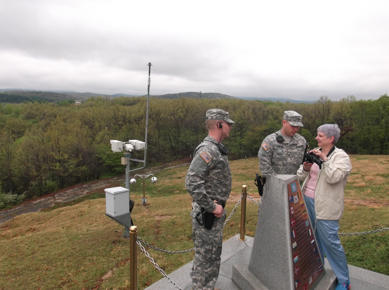
From the Panmunjeom village we drove to an observation area for a view of the North Korean side of the border. The soldiers were our miltary escorts.
On our return to Camp Bonifas we drove past the Freedom Bridge [also known as the Bridge of No Return]. This border crossing was the place where POW'S were exchanged between the North and the South. It was called the Bridge of No Return because if the prisoners decided to stay on either the north or south side of the bridge where they had been captured they would never be allowed to return to the other side. There were about one dozen American soldiers who were captured by the North Koreans who defected to North Korea and were never allowed to return home after they made that decision.

After returning to Camp Bonifas we changed back to our tour bus and then went on to visit the 3rd Infiltration Tunnel, which was a tunnel dug under the DMZ by the North Koreans [one of four such tunnels that have been located thus far.] These tunnels were dug under the DMZ to allow the infiltration of North Korean troops into South Korea in the event of war. The South Koreans dug tunnels on a slope downwards several hundred yards to intersect with the North Korean tunnels which they blocked off and closed. We hiked down this tunnel to enter the tunnel dug by the North Koreans. It was difficult for me to walk down the steep tunnel to the North Korean tunnel as it was only slightly over five feet high which required me to bend over while walking, and basically "duck walk" the entire distance. My legs got quite a work out.
We also stopped at the Dora Observatory, which is an observation post that overlooks the North Korean side of the border. There were many Korean and Chinese tourists there as they are not allowed to enter the DMZ as our tour had, so that was their only opportunity to view the North Korean side of the border.
We stopped for lunch at a Korean restaurant near the border crossing to the industrial area that is inside North Korea. The crossing was closed because the North Koreans had closed the industrial complex as part of their warmongering campaign.

After lunch we travelled to the Dorasan Station which is a modern train station that was built as part of an agreement between North and South Korea to complete a rail line between Seoul and Pyongyang, the capital of North Korea. After completion of this rail link you would be able to travel by rail from South Korea thru North Korea and on to China, Russia and Europe. It was hoped by the South Koreans that after this rail link was completed that it would lead to future reunification with North Korea. Unfortunately, after the rail link and station were completed in South Korea, North Korea decided against opening the rail line, and now Dorasan Station is a modern train station to nowhere. It is now a popular South Korean tourist site where they enjoy taking their pictures on the abandoned rail line. These pictures show our tour guide in front of a map of the proposed rail line, and pictures inside the station and outside on the rail line. This was also the first occasion, of several, in my trip to South Korea that I was approached by teenagers wanting to take their picture with me. I always replied that they could, if I could take a picture of them also.


Seoul is a very modern city, having been almost totally destroyed in the Korean War. I stayed in a very upscale area of the city called Myeong-dong which is the glitzy, upscale shopping and government area of Seoul. Just a short walk from my hotel was the Seoul City Hall. The original building is now dwarfed by a new, modern building in the form of a breaking wave. In front of the City Hall is a large open green space where free concerts ranging from opera to rock are held each night and on weekends. Couples and families come and picnic and listen to the music.


Across the street from the Seoul Plaza in front of the City Hall was the entrance to the Deoksugung Palace which was originally built in 1593 after all of the rest of the royal palaces were destroyed by Japanese invaders. In addition to the original buildings, newer buildings were erected in the early 1900's and follow the design of european regal habitations. Several times each day a changing of the guard ceremony is held at the entrance gate to the palace grounds with costumed soldiers and bandsmen.


Changdeokgung Palace, another one of the four main royal palaces in Seoul, was a short subway ride from my hotel. The palace complex was built in the early 15th century, but was completely destroyed in the Japanese invasion in the 1590's and served as a secondary palace to the main palace [Gyeongbokgung.] It was rebuilt after the Japanese destruction, and served as a residence of members of the royal family into the 20th century. It is a World Heritage property, and is touted as the most beautiful of the four main palaces in Seoul.


The grandest of the four main palaces in Seoul is the Gyeongbokgung Palace. It was originally built in 1395. It was burnt down during the Japanese invasion in 1592, and laid in ruins for almost 300 years before it was rebuilt. During Japanese colonial rule in the 1900's it was destroyed once again. It has now been rebuilt and is the site of several museums. The day I visited there were hundreds of school children visiting. The elementary school age children had different colored t-shirts for each different class so the kids would not get mixed up with children from other classes. High school age students were in school uniforms. I had numerous requests to have my picture taken with different groups of kids, I started to feel like a rock star.
Outside one of the palace side entrance gates I came across these three police officers. It was the first time I have ever seen police officers patrolling on roller blades.

On the Sunday that I was in South Korea I took a day trip to the city of Suwon which is about one hour by train from Seoul. It was definitely outside my comfort zone as I had to make several connections during the trip, and outside of Seoul English is not widely spoken. During the entire day outside of the city of Seoul I did not see another Westerner. Suwon is a fortress city built by one of the rulers in the 18th century who decided to move the capital there from Seoul. He died before the palace complex was completed, and the capital remained in Seoul. The fortress complex is a World Heritage site. The complex is surrounded by a wall which is about three miles in circumference. I hiked the entire length of the wall, then visited the buildings within the walls. The fortress walls resembled a mini Great Wall of China, with large entrance gates on four sides of the wall complex, with numerous guard towers and weapons ports throughout the length of the wall.


After walking along the wall for about one hour I stopped at a small corner guard pagoda to rest and drink some water. Inside the pagoda was a family with children and grandmother eating cucumbers and moon pies. As I got my water out of my backpack, the mother came over to me and offered me a raw, peeled cucumber and moon pie to eat. She took a half full water bottle and mixed in a liquid fruit concentrate that I believed she was saying she made herself. Although I'm not much into raw cucumbers, I ate it and the moon pie which was really good. The fruit drink was delicious. As the family only spoke Korean, I felt badly because I forgot how to say "thank-you" in Korean. As they were leaving I waved and said goodby, and one of the kids [about 9 years old] waved back and said goodby in English, so I hope she told her family how appreciative I was of the kindness that they showed to me.
The last morning that I was in Seoul I had a couple of hours to kill before I had to leave for the airport so I walked about one-half mile to the hill in the center of Seoul called Namsan. On the way I passed a group of store employees on the sidewalk getting ready to open the business for the day. The boss was giving them a pep talk, and they were doing exercises before going into the store for work. How different than in the U.S. At the bottom of the hill I rode up an inclined elevator to the lower station of a cable car that took me to the top of the mountain where an observation tower and restaurants are located. There is also a large park area, and numerous hiking circuits on the hill. There is a 360 degree view of Seoul, although it was a bit hazy that morning so the views were not that great. The photo I have included looks down on the Myeong-dong area where my hotel was located. The top of Namsan is a popular dating area, and it is tradition that the dating couples attach a padlock with an inscribed message and their names to the railings and other tree like objects in the area. They call it "locking your love."


I had a great time during the week that I spent in South Korea, and I look forward to returning and seeing the many sights that I missed on this first trip.